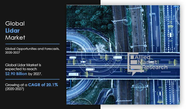
In recent years, Light Detection and Ranging technology, commonly known as LiDAR, has burgeoned into a vital instrument across multiple sectors, from autonomous vehicles to agricultural management. As the demand for precise and efficient data collection escalates, so does the competition among manufacturers to develop the most advanced LiDAR systems. This discourse endeavors to illuminate what constitutes the best LiDAR in the current market, analyzing various aspects such as technological advancements, application versatility, accuracy, and cost-effectiveness.
Technological Advancements: A Paradigm Shift
The essence of LiDAR lies in its ability to harness light pulses—emitted by a laser—to measure distances to the Earth’s surface. This intricate mechanism enables users to generate three-dimensional information about physical characteristics. Modern advancements have catalyzed a shift in perspectives regarding LiDAR’s applications. For instance, solid-state LiDAR, characterized by its lack of moving parts, promises enhanced reliability and durability, making it particularly intriguing for mobile applications in autonomous driving.
Companies such as Velodyne and Luminar have pioneered advancements in this domain, with Velodyne’s HDL-64E and Luminar’s Iris systems exemplifying cutting-edge technology capable of delivering real-time, four-dimensional mapping. The introduction of frequency modulated continuous wave (FMCW) LiDAR is another breakthrough that permits the capture of high-resolution images in varied lighting and atmospheric conditions, thereby expanding the operational boundaries for industries reliant on precision measurements.
Application Versatility: From Nature to Urban Landscapes
The eclectic nature of LiDAR systems lends them to myriad applications ranging from environmental monitoring to urban planning. For instance, the use of airborne LiDAR technology has revolutionized forestry management, allowing ecologists to quantify forest biomass with unprecedented accuracy. Similarly, in the realm of urban development, LiDAR’s ability to provide detailed topographic data aids in effective planning and management of infrastructures.
With a growing interest in drone technology, companies like senseFly are deploying miniaturized LiDAR systems suitable for light drones. This democratization of LiDAR technology allows smaller enterprises to harness sophisticated mapping capabilities without the substantial overhead typically associated with larger systems. Thus, the best LiDAR systems are not merely defined by their performance metrics but also by their capacity to adapt to various operational environments.
Accuracy: The Cornerstone of LiDAR Efficacy
The precision of LiDAR measurements is paramount, as even minuscule errors can have significant ramifications, particularly in fields such as civil engineering and disaster management. When assessing the best LiDAR systems, factors such as point density, range, and resolution must be scrutinized. For example, the Riegl VZ-400i is renowned for its exceptional accuracy and versatility, capable of producing high-resolution 3D point clouds even in challenging terrains.
Complementing conventional LiDAR systems with additional sensors, such as cameras and GNSS/IMU units, augments the overall accuracy and integrity of the data collected. This multi-sensor approach is gaining traction, as it not only bolsters data reliability but also enriches the datasets, allowing for more complex analyses and applications. In the quest for the best LiDAR system, accuracy is unequivocally non-negotiable.
Cost-Effectiveness: Value in the Era of Innovation
The financial implications of acquiring and operating a LiDAR system extend beyond the initial investment. Budget-conscious organizations must weigh the long-term value and potential return on investment. The emergence of lower-cost alternatives has democratized access to this advanced technology, while still delivering commendable performance. Systems such as the GeoSLAM ZEB-HORIZON have garnered attention for providing superior mapping capabilities at a fraction of the cost of traditional systems.
Enhancing cost-effectiveness is the increasing trend toward subscription-based or as-a-service models, allowing users to access LiDAR technology without incurring prohibitive upfront costs. This shift not only affords organizations flexibility but also mitigates the risks associated with rapid technological evolution, where hardware becomes obsolete at daunting speeds.
Future Trends: Where Do We Go from Here?
A burgeoning fascination with AI integration into LiDAR technology is emerging. Machine learning algorithms promise the potential to automate data processing, enabling users to rapidly derive insights from complex datasets. Such integrations indicate a future where LiDAR is not merely a passive collection tool but an active participant in data-driven decision-making processes.
Furthermore, with the continuous evolution of 5G technology, the prospect of real-time data processing and instantaneous feedback transforms how industries deploy LiDAR systems. The implication extends beyond immediacy; it opens avenues for remote monitoring, which could prove invaluable in disaster response scenarios.
Conclusion: The Best of the Best
While identifying the unequivocal “best” LiDAR system in the burgeoning market is an arduous task due to the myriad of applications and evolving technologies, exceptional systems like the Velodyne HDL-64E, Riegl VZ-400i, and Luminar Iris stand out due to their technological innovations, accuracy, application versatility, and cost-effectiveness. Ultimately, the best LiDAR system is one that aligns seamlessly with the user’s unique requirements while leveraging the continual advancements within this dynamic field. LiDAR has unlocked a realm of possibilities, promising to reshape industries and redefine our understanding of geography and spatial dynamics.