Short Answer
Definition of Sea-Level Rise and Its Significance
Sea-level rise refers to the gradual increase in the average height of the world’s oceans, a phenomenon that has garnered extensive attention from scientists and the public alike in recent decades. This upward trend in ocean levels carries profound consequences for coastal ecosystems, human settlements, and global economic systems. The study of sea-level rise involves identifying and understanding the various natural and human-induced factors that contribute to this complex environmental challenge.
Primary Causes of Sea-Level Rise
The increase in sea levels is primarily driven by two major processes:
- Thermal Expansion:
As global temperatures climb due to climate change, ocean water warms and expands, leading to a rise in sea volume. - Melting of Ice Masses:
The accelerated melting of glaciers, polar ice sheets, and other terrestrial ice reservoirs adds significant volumes of freshwater to the oceans.
These mechanisms do not affect all regions equally; variations in geography and hydrology create distinct patterns of sea-level change worldwide.
Techniques for Measuring Sea-Level Changes
Geophysicists utilize advanced technologies to detect and analyze sea-level variations with high precision. One key method is satellite altimetry, which measures the height of the sea surface from space, providing detailed temporal data over both short and extended periods. This approach enables researchers to track subtle changes and regional differences in sea-level rise, enhancing the understanding of underlying processes.
Fingerprinting Sea-Level Rise: Analytical Approaches
The concept of “fingerprinting” sea-level rise involves dissecting the individual contributions of various sources to the overall increase in ocean levels. This is achieved through sophisticated numerical models that simulate the responses of oceanic and atmospheric systems under different climate scenarios. These models incorporate physical and geophysical factors such as coastal topography, ocean currents, and gravitational forces, allowing scientists to predict how specific regions will respond to identical climatic changes.
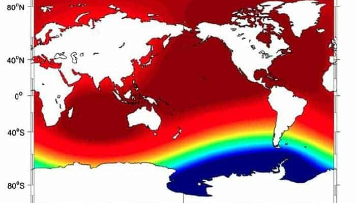
Regional Variability and Gravitational Effects
One notable finding in sea-level research is the uneven distribution of rise across the globe. This heterogeneity is often explained by gravitational effects linked to the redistribution of Earth’s mass. For example, as the Antarctic ice sheet loses mass, its gravitational attraction weakens, causing local sea levels nearby to fall, while more distant areas experience higher sea-level increases. This phenomenon highlights the interconnected nature of Earth’s systems and the complex feedbacks involved.
Impact on Coastal Sedimentary and Ecological Systems
Rising sea levels also influence sediment transport and erosion along coastlines, altering the physical landscape and affecting coastal habitats. Changes in salinity and nutrient flows can disrupt ecosystems that depend on stable environmental conditions. Consequently, geophysical studies often integrate ecological data to provide a comprehensive understanding of how biological communities respond to physical changes in their environment.
Societal Implications of Sea-Level Rise
As human populations increasingly concentrate in coastal zones, the risks posed by rising seas become more urgent. The challenges include protecting infrastructure, managing displacement and migration, and ensuring sustainable development. Geophysicists emphasize the need for informed policy-making that incorporates scientific insights to mitigate these impacts effectively. This interdisciplinary approach bridges environmental science with socio-economic planning, underscoring the broader relevance of sea-level rise beyond academic research.
Technological Innovations in Monitoring and Mitigation
Advancements in technology, such as drone surveillance and enhanced modeling software, have revolutionized the monitoring of sea-level changes. These tools provide real-time data that support adaptive management strategies, enabling a shift from reactive responses to proactive planning. Such innovations are critical for improving resilience and preparedness in the face of ongoing environmental transformations.
Conclusion: The Importance of Interdisciplinary Collaboration
The scientific endeavor to fingerprint sea-level rise reveals the intricate and multifaceted nature of this global issue. By unraveling the mechanisms behind ocean level increases and exploring their environmental and societal consequences, researchers highlight the necessity of collaboration across disciplines. Continued academic investigation, coupled with public engagement and policy development, is essential to build resilience and address the challenges posed by a changing planet.


Leave a Reply